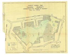
Maps

Elements area

Taxonomy

Code

Scope note(s)

    Source note(s)

      Display note(s)

        Hierarchical terms

        Maps

          Equivalent terms

          Maps

            Associated terms

            Maps

              10 Archival description results for Maps

              CA PR104 · Fonds · 1858-1945

              Collection consists of bound and unbound maps of Victoria and Esquimalt, a Victoria directory from 1860, a document showing polling divisions in Esquimalt (1925), and photographs of Wolfenden family members and B. C. Land and Investment Agency.

              City of Victoria Archives
              CA AC001 · Collection · ca. 1850-1990

              The collection consists of single or small accumulations of photographs, textual records, maps, and other material donated to the Esquimalt Municipal Archives by unknown private individuals, businesses, and organizations over many years.

              Esquimalt (B.C.). Town Clerk's Department. Esquimalt Municipal Archives
              CA PR491 · Fonds · 1925-1950

              Collection consists of Fire Insurance maps of Victoria and Esquimalt that show details such as building construction, alarms, heating, hydrants and fire mains.

              Louise Muir Fonds
              CA PR140 · Fonds · 1896-[ca. 1960]

              The fonds consists of photographs of Old Esquimalt Village, the Point Ellice Bridge disaster, football clubs Ab March played on, and staff and buildings of Esquimalt businesses. Fonds includes a photocopied map relating to the expropriation of Esquimalt Village during World War II.

              Muir, Louise
              Michael Pope fonds
              CA PR079 · Fonds · [ca. 1980]-1987

              The fonds consists of photographs of buildings on Cole Island in Esquimalt Harbour, and a map showing their locations.

              Pope, Michael